Day by day itinerary
Day 01: - Arrival Kathmandu, transfer to Hotel, overnight hotel (B).
Day 02: To Day 03: – Preparation day in Kathmandu - On this day you will be briefed by our guide about expeditions in the Tourism ministry (BB).
Day 04: – Kathmandu to Tumlingtar 510 m, 40 minutes by flight (B/L/D).
Day 05: – Tumlingtar to Num (1500 m) by Jeep 5 hours drive, overnight in Lodge/Tea house, (B/L/D).
Day 06: – Num to Seeduwa (1540 m), overnight in Lodge/Tea house, (B/L/D).
Day 07: – Seduwa to Tashigaon (2070 m), overnight in Lodge/Tea house, (B/L/D).
Day 08: – Tashigaon to Khongma (3560 m), overnight in Lodge/Tea house, (B/L/D).
Day 09: – Khongma to Mumbuk (3550 m), overnight in Lodge/Tea house, (B/L/D).
Day 10: – Mumbuk to Nghe Kharka (3750 m), overnight in Lodge/Tea house, (B/L/D).
Day 11: – Nghe Kharka to Shersong (4610 m), overnight in Lodge/Tea house, (B/L/D).
Day 12: - Rest day for acclimatization, (B/L/D).
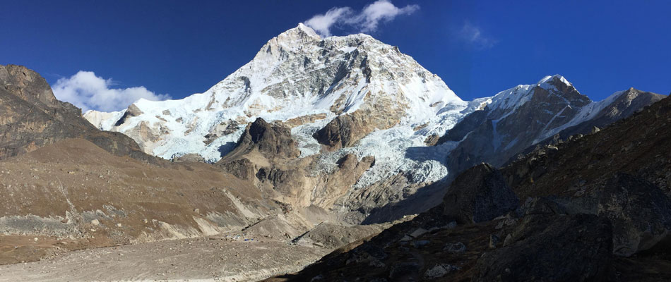
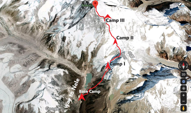
Day 13: – Shersong to Makalu Base Camp (5050 m), overnight in Lodge/Tea house, (B/L/D).
Day 14: To Day 43: Climbing Period for Makalu (8463m), Overnight in Tented Camp, (B/L/D).
Day 44: – Makalu Base Camp to Yangle Kharka (3600 m), overnight in Lodge/Tea house, (B/L/D).
Day 45: – Yangle Kharka to Kongma la (3560 m), overnight Lodge/Guest house, (B/L/D).
Day 46: – Kongma La to Seduwa (1540 m), overnight in Lodge/Tea house, (B/L/D).
Day 47: – Seduwa to Num (1500 m), overnight in Lodge/Tea house, (B/L/D).
Day 48: – Num to Tumlingtar(1840), By Jeep to Tumlingtar 5/ 6 hours drive, overnight in Lodge/Tea house, (B/L/D).
Day 49: – Tumlingtar to Kathmandu (1100 m), overnight in Lodge/Tea house (B/L/D).
Day 50: – Leisure in Kathmandu, overnight in hotel (BB).
Day 51: - Departure from Kathmandu (B).
Detail Itinerary
Day 01: - Arrival Kathmandu, transfer to Hotel, overnight hotel (B).
Day 02: To Day 03: – Preparation day in Kathmandu - On this day you will be briefed by our guide about expeditions in the Tourism ministry (BB).
Day 04: – Kathmandu to Tumlingtar 510 m, 40 minutes by flight (B/L/D).
Day 05: – Tumlingtar to Num (1500 m) by Jeep 5 hours drive, overnight in Lodge/Tea house, (B/L/D).
Day 06: – Num to Seeduwa (1540 m), overnight in Lodge/Tea house, (B/L/D).
Day 07: – Seduwa to Tashigaon (2070 m), overnight in Lodge/Tea house, (B/L/D).
Day 08: – Tashigaon to Khongma (3560 m), overnight in Lodge/Tea house, (B/L/D).
Day 09: – Khongma to Mumbuk (3550 m), overnight in Lodge/Tea house, (B/L/D).
Day 10: – Mumbuk to Nghe Kharka (3750 m), overnight in Lodge/Tea house, (B/L/D).
Day 11: – Nghe Kharka to Shersong (4610 m), overnight in Lodge/Tea house, (B/L/D).
Day 12: - Rest day for acclimatization, (B/L/D).
Day 13: – Shersong to Makalu Base Camp (5050 m), overnight in Lodge/Tea house, (B/L/D).
Day 14: To Day 43: Climbing Period for Makalu (8463 m), Overnight in Tented Camp, (B/L/D).
Day 44: – Makalu Base Camp to Yangle Kharka (3600 m), overnight in Lodge/Tea house, (B/L/D).
Day 45: – Yangle Kharka to Kongma la (3560 m), overnight Lodge/Guest house, (B/L/D).
Day 46: – Kongma La to Seduwa (1540 m), overnight in Lodge/Tea house, (B/L/D).
Day 47: – Seduwa to Num (1500 m), overnight in Lodge/Tea house, (B/L/D).
Day 48: – Num to Tumlingtar(1840), By Jeep to Tumlingtar 5/ 6 hours drive, overnight in Lodge/Tea house, (B/L/D).
Day 49: – Tumlingtar to Kathmandu (1100 m), overnight in Lodge/Tea house (B/L/D).
Day 50: – Leisure in Kathmandu, overnight in hotel (BB).
Day 51: - Departure from Kathmandu (B).
Useful information related to this trip.
Please click on title to read details
-
What kind of Experience Requirement??
What kind of Experience Requirement?
To join the Peak climbing or expedition you will need to have extensive mountaineering experience.
- Adjustment in the team members and Sherpa Staffs.
- High and extreme Trekking experiences in the Himalayas.
- Responsible for self control and safety.
- Mentally and physically fitness.
-
What is the weather like and best time to Climbing?
What is the weather like and best time to Climbing?
Nepal has four season such as autumn (Sep. Nov. and Oct.), winter (Dec. Jan. and Feb.), spring (March, April and May) and monsoon (June, July, and Aug.). During the autumn season the nights are cold in mountains but the bright sun makes for pleasant daytime temperatures. At higher altitudes temperature range from about 20°C down to perhaps -10°C at night. Morning is usually clear, and then clouds build up during the afternoon, disappearing at night to reveal spectacular starry skies.
During the winter season high passes, especially the Thorong-la pass, Dhaulagiri circuit, Tilicho (musukanta Pass) in Annapurna trekking, Chola Pass, Renjola Pass, Khongmola pass, Amalaptse pass, Roywalling pass, Serpeni col in Everest reason, Lauribina pass, Ganjala pass, Gosaikunda pass in Langtang, Larky Pass in Manaslu, are usually closed. Short and easy trek in middle hills is the best on this time. Heavy snowfalls do especially during the January, February and March in mountain areas.
Spring season bring warmer weather but more frequent storms and considerable snowfall at higher altitude. Birds and flowers, especially rhododendrons, are seen at the lower altitudes. Toward the end of March, haze-caused by dust from the plains of India and smoke from local fires often obscure distant views. In addition it becomes much warmer in the region below 3000 ft. Trekking in Monsoon (June to Aug.) can be undertaken by the keen or experienced. Rain, mist and fog can be expected almost daily, but clouds part occasionally to give spectacular views of the mountains. The floras are usually at their most colorful. Leeches abound in middle elevation forests. Mountain weather is highly unpredictable. Classic signs of a storm approaching such as cirrus clouded sky or a fall in barometric pressure, can be misleading.
Best time for climbing in Nepal is spring (March, April and May) bring warmer weather and secondly autumn season (September, October-November) fair whether in Nepal. You need to be prepared for sudden weather changes while trekking and climbing. That's why trekking equipment should be chosen carefully before the trip. Sudden rain storms or snow are always a possibility which needs to be considered. The weather during the trekking season is somewhat more stable. "Asian Hiking Team" pays big attention to weather forecast.
-
How difficult are the climbing?
How difficult are the climbing?
Difficulty of the climbing or expedition depends on the peak. Trekking peaks are easier then high mountain expedition but some of less high peak also technical for climbing;
a) Length of trek and walking days
b) Which Mountain and altitude conditions
c) Average altitude, maximum altitude and average gain/loss per day
d) Likely prevailing weather conditions and temperature range
e) Remoteness of local services and general level of comfort
f) Technical or easy climbing mountain
Grade A – “Moderate”
Grade B - “Technical”
Grade C – “Technical Plus”
Grade D – "Tough climbing"
-
What kind of Accommodation during the trekking and Climbing?
What kind of Accommodation during the trekking and Climbing?
During the trekking it is possible Guest house/Lodge facilities some of major trekking area. In the guest house / Lodge have running hot and cold water facilities. Private rooms are available in most guest house/ Lodge. Most bathrooms are shared. Many years experience of Trekking field of organizing various treks in Nepal assures you that we have chosen for our treks the cleanest and most hygienically kept Guest Houses /Lodge with friendly atmosphere and best views. From the base camp we need to full board camping. Camping is fully organized and supported, with a team of guides, cooks, Sherpas and porters to accompany you. Our porters carry all the trekking gear, food, fuel and personal belongings. Our cooks prepare hot meals. At night, tents for dining, sleeping and ablutions tents are provided and set up, mattresses and down-filled sleeping bags, tables and seating. In a typical camping trek, we start the day around 6/7 AM with a cup of hot tea. You are then provided with a bowl of warm water for washing. Then trekkers enjoy breakfast before leaving camp. The trek begins around 7.30 - 8 a.m. Trekkers can set their pace for pausing and sightseeing and the walk to the lunch spot will normally take 3 hours. On arrival, you are served hot lunch. In the afternoon, after walking for another 3 to 4 hours, you arrive at the next camp around 4/5PM. Tea & snacks are served while our staff readies the camp. Dinner time is around 6/7 PM in the dining tent, lit with lanterns and comfortably furnished.
-
Where do we eat our meals and what kind of food is available?
Where do we eat our meals and what kind of food is available?
During a tea house trekking you will have breakfast and dinner in the guest house/ Lodge, lunch will be eaten at one of the trail side restaurants. Every Guest house House serves the traditional Nepali meal Dal Bhat Tarkari (rice, curry and lentil soup). All Guest Houses of our routs have variety of different food items, such as rice, vegetables, noodles, potatoes and soup. Many of them have western food on menu. Soft drinks, snacks, wine and beer are available in most of the guest houses and trail side restaurants. Food safety is always a big concern and we take it very seriously. That is why we have chosen the cleanest and most hygienically kept Hotel for our routes. During the camping we prepare food by our cook so that we shopping food items as your demand before trip start.
-
What are the sources of drinking water supply during climbing?
What are the sources of drinking water supply during climbing?
All guest houses have boiled water for trekkers and climbing. And on the main trekking routes it is possible bolter mineral water to drink. We recommend to your clients not use bolter water, it is not environment friendly. You can use Iodine table or others purify drops. It is noticeable that during the camping we provide the boiled water to our clients.
-
What kind of Equipment need during Climbing?
What kind of Equipment need during Climbing?
Clothes:- liner gloves, fleece or wool mittens, Gore-Tex over mitts, light-weight socks, heavy-weight socks, Hat or cap for the sun, Fleece hat or balaclava, Polypropylene tops, Long sleeve shirts, Fleece jacket, Windproof Gore-Tex parka, Down jacket, light hiking, fleece pants, windproof Gore-Tex pants, synthetic underwear tops and bottoms.
PERSONAL: - Camera, video camera, extra batteries, Reading material, Personal first-aid kit, Diary and writing material, Sunscreen and lip protection (SPF 40), Pee bottle, Personal hygiene kit, Note books, panicle, reading books, Batteries for headlamp or other.
TECHNICAL GEAR:- Ice axe, Crampons, Ice tool, Harness, Ice screws, Carabineers, Locking carabineers, Short-5- millimeter accessory cords, Slings.
Others:- Sun glacier glasses or equivalent, Ski goggles, Headlamp with spare bulb, Pocket knife, Sleeping bag (-20ºC), Water bottles - Thermo, Plastic mountaineering boots, Trekking boots, Gaiters or super gaiters, Large backpack (80 lts.), Small backpack ( 40-50 lts.), large duffle bags or similar with 2-way zippers and lock, Small bag with 2-way zippers and lock, Plastic bags.
-
What sort of experience does Climbing Guides/ high-land porters have?
What sort of experience does Climbing Guides/ high-land porters have?
Climbing Sardar / Guides have many years of climbingexperience all over Nepal mountain. Most of them have been spending years climbing the peak all over the country and aboard. Our guides are trained in basic, advance mountaineering training, first aid and know how to handle any serious situation. All our guides speak English and happy to share their deep knowledge of rock, ice climbing with you. We need to provide guides who can get people feel involved in what they are experiencing, explain it thoroughly and keep them entertained. They know very well how to facilitate running smooth and safe trip appreciating the beauty of the Himalayas. All our high-land staffs have well experience, equipment with insurance for any mishap. Their first hand experience, local knowledge, expertise and humor on climbs are invaluable.
-
What happens in case of emergency and Rescue?
What happens in case of emergency and Rescue?
"Asian Hiking Team" company is prepared for any emergency situation and knows how to handle it. Our guides are trained in first aid and can deal with most of the basic ailments that occur during a trek and directly connection in main office Kathmandu each day if possible. Every client should have his own insurance before coming to Nepal for case of emergency. Our all staff has insurance in case of emergency. In Extreme emergency rescue if the urgent helicopter evacuation require between 6000m to 7000m, we can arrange Helicopter Rescue, may its cover by your insurance. Weather Forecast for the climbing weather report we advise you to use from Meteo Swiss or from Austria or we can help you to get in contact with them. For the prompt weather Forecast send to you by SMS or email or on phone to prepare your summit attempt.
We also strongly recommend that you take out trip cancellation, air ambulance /helicopter rescue insurance. You should be aware that some policies do not include, or restrict, cover for this type of travel. You must ensure that the policy you do take provides an adequate level of protection and covers you for the activities involved. You must carry proof of insurance (e.g. your insurance certificate) with you on the holiday; if you cannot provide this at the start of the holiday, you will be required to take out a suitable policy at that time. If this is not done or impossible for practical reasons, then you will not be allowed to continue with our trekking/climbing trips and will not be entitled to any refund for services not provided. Your insurance must include emergency air ambulance/helicopter rescue services.
-
How we communication in case of emergency?
How we communication in case of emergency?
Land-line and mobile phone services are available in Nepal. Network covers Kathmandu, major cities and towns and most of Nepal, except some rural Himalayan places. Nepal Telecommunications Corporation is the national service supplier. There are also private service suppliers such as Hotels and private communication centers also provide long distance telephone, internet and fax facilities.
For calling from outside, country code for Nepal is “977” and the area code for Kathmandu is “1”. To call Nepal from other countries: 00 + country code (977) + city code + telephone number. Example to call us: 00-977-1-4420858. Call from Nepal city code and telephone number, example to call us; 01-4420858. We provide to our clients stale-light phone for high expedition so it’s easy to talk in base camp staff and Kathmandu.
-
What type of service you can provide?
What type of service you can provide?
Our services are intended to offer quality and value for money, together with a rich, varied and a rewarding experience. We have built our reputation as the best travel agent in the country for the best service provider. Our prices of all the climbing are highly competitive and unmatched with any other local tour operators. We operate climbing with two different kinds; Full organizes service - you want to be free from all concerns to enjoy this experience to the fullest. Base Camp service - you prefer to climb yourself but want to fix base camp and take benefit from us official documentation, transportation, equipments, all management into base camp.
-
Is it including High altitude climbing Sherpa Bonus?
Is it including High altitude climbing Sherpa Bonus?
As per the requirement of clients for the High altitude climbing Sherpa, they are paid for their equipment allowance, daily wages, food and insurance coverage etc. In addition Sherpa bonus as Tips is under the Mountaineering system to encourage Sherpas for their better motivation towards the summit bid. Therefore for the clients general information the Sherpa bonus amount is specified in each mountain program.
-
How much NMA Peak Climbing Royalty?
How much NMA Peak Climbing Royalty?
The climbing fees structure of NMA peak:
Group "A" Peaks
Royalty for up to seven members (U.S Dollars) 500.00
Royalty for each additional member up to 12 person (U.S. Dollars) 100.00
Royalty for Group “B” Peaks
1-4 Persons 350.00 Only
5-8 Persons 350.00 plus 40.00 (Per person)
9-12 Persons 510.00 plus 25.00 (Per person)
Note: Maximum number of members in team is 12.
Garbage deposit for all 33 NMA Peaks
An amount of US$250.00 deposit to NMA as garbage deposited to get permit to all 33 NMA peaks.
How much mountaineering royalty?
Royalty for Foreign Climber per Person in US Dollar
1. Everest Normal Route Spring Season 11000, Autumn Season 5500, Winter/Summer 2750
2. Everest Other Route Spring Season 10000, Autumn Season 5000, Winter/Summer 2500
3. Others Mountain more than 8000 m. Spring Season 1800, Autumn Season 900, Winter/Summer 450
4. 7501m. - 7999 m. Spring Season 600, Autumn Season 300, Winter/Summer 150
5. 7000 m. - 7500 m. Spring Season 500, Autumn Season 250, Winter/Summer 125
6. 6501 m. - 6999 m. Spring Season 400, Autumn Season 200, Winter/Summer 100
7. Mt. Amadablam (6812m.) Spring Season 400, Autumn Season 400, Winter/Summer 200
8. Less than 6500 m. Spring Season 250, Autumn Season 125, Winter/Summer 70
The provision of Royalty for foreign climbers will come into effect from 1 January 2015 (B.S. 20171/09/17)
Royalty for Nepalese Climber per Person in Nepalese Rupees.
1. Everest Normal Route Spring Season 75000, Autumn Season 37500, Winter/Summer 18250
2. Everest Other Route Spring Season 60000, Autumn Season 30000, Winter/Summer 15000
3. Others Mountain more than 8000 m. Spring Season 10000, Autumn Season 5000, Winter/Summer 2500
4. 7501m. - 7999 m. Spring Season 8000, Autumn Season 4000, Winter/Summer 2000
5. 7000 m. - 7500 m. Spring Season 6000, Autumn Season 3000, Winter/Summer 1500
6. 6501 m. - 6999 m. Spring Season 5000, Autumn Season 2500, Winter/Summer 1250
7. Mt. Amadablam (6812m.) Spring Season 8000, Autumn Season 8000, Winter/Summer 4000
8. Less than 6500 m. Spring Season 4000, Autumn Season 2000, Winter/Summer 1000
- Royalty for Nepalese climbers will come into effect from 13 February 2014 (B.S. 20170/11/01).
- The Mountaineering Royalty has been totally waived to the mountains situated on Mid Western and Far Western Development Region of Nepal for 5 years effecting from 2070/04/01-2075/03/32 (16 July 2013 to 15 July 2018).
- Ministry of Culture, Tourism and Civil Aviation of Nepal has expected that the timely amendment in Royalty for mountaineering in Nepal will be the milestone for the promotion of Nepalese Mountaineering Sector around the World.
- As per the decision of secretary level dated 2071/1/16, the insurance amount for Sardar, mountain guide and high altitude walker is fixed as Rs 15 lakhs. Similarly, medical insurance is fixed as Rs 4 lakhs.
- Maximum no. of members in a team is 15.
-
What document we need for Permit?
What document we need for Permit?
a) Submit the Personal Registration Form :
b) Passport copy:
c) Passport size Picture:
e) Health Certificate.
d) Perosnal Bio-data.
-
How can I book Climbing?
How can I book Climbing?
All bookings are made with Asian Hiking Team Pvt. Ltd. based at Thamel, Kathmandu, Nepal. Trip is reference to as Company in booking conditions. To book your holiday you need to send us completed booking (inquiry) form or directly email us with details. For more information click here ».